A settlement Cissa Portunata was in Roman times situated in the northern part of the island of Pag, and gave its name-till the 14th century-to the whole island. Linguistic investigations confirmed that the name Cissa is preserved in modern name of the Caska cove in the very recess of the Pag bay, abounding in numerous traces of life from the Roman period. The name Cissa was inherited from prehistory, while the adjective portunata probably designated a settlement naturally endowed with harbors. If we take into account that many sheltered harbors are indeed concentrated around the Novalja field, such as Stara Novalja in the north, Novalja in the west, and the Pag bay with Zrće and Caska coves in the south, we may presume that the whole territory actually functioned as an integrated whole.
The names Novalja and Stara Novalja derive from Latin navalia, generally used to determine a place for repair and supply of ships. But the word often described a place where the ships were pulled out on land and sheltered below covered repositories during winter, occasionally even a military harbor.
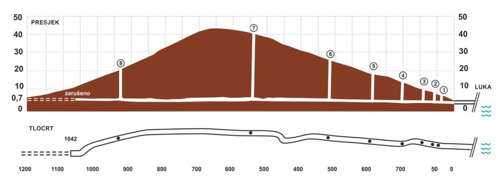
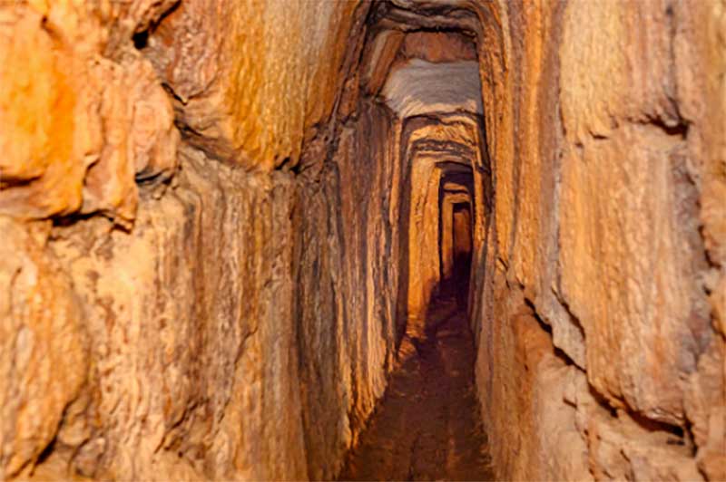
The Roman aqueduct, a subterranean tunnel c. 1050 long and carved into a live rock, is unquestionably the most impressive and best preserved Roman construction in Novalja.
Its average breadth is c. 0,6 meters, while its height varies from c. 1 to c. 2,3 m. It was probably constructed during the 1st century AD, but we do not know for how long it conveyed water from the Novalja field to the coast, at least for now. The analysis of its very well preserved wooden roof-construction, which stopped in one place the collapse of the material from a crevice or a smaller cavern, showed that it was still in use in the beginning of the 3rd century. During the late antiquity (5th and 6th century AD), the bay of Novalja was an important harbor, while the settlement on the territory of Novalja was perhaps also an important religious destination, which makes it probable that the aqueduct was still operational. With the passage of time every trace of the existence of the aqueduct was lost, both on the surface and in peoples memories. There are stories from the 19th century of a child falling into the aqueduct, which enabled the locals to discover an impressive subterranean canal. At first, fantastic stories about the canal spread; than the scientist explained what it really is and it received a folk name Talijanova buža. This must have happened during the first half of the century, since it was drawn and described in 1853 by Mijat Sabljar, commissioner of the National Museum in Zagreb,in his sketch-book, which is preserved until today.
Dating the construction of the aqueduct in the 1st century AD was suggested by the seal on a Roman tile used repeatedly to support the roof of the canal or to level its floor. The seal reads AFAESONIAF, suggesting the name of Aulus Fesonius, a son of Aulus (Aulus Faesonius Auli filius), who owned a brickyard at that time somewhere in the northern Adriatic.
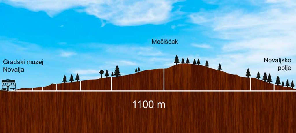
Nine vertical quadrangular shafts, so-called odiha, were made for the construction of the subterranean canal. The highest of them is on the summit of mount Močišćak, seperating Novalja from its field, 44 meters high. In later periods the shafts were probably used for clearing up and maintenance of the aqueduct, and even today the slots for feet-tops are visible, used for entering and leaving the subterranean canal. There must have been a supervisor called curator aquarum in Novalja, who was responsible for the maintenance of the construction.
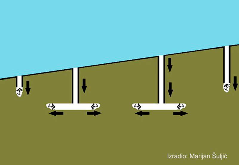
From where exactly the aqueduct acquired water is still unknown, but it is probable that the subterranean and storm-waters from the field were used, as well as the water from the creek that flows through its middle. A proof for this theory is offered by a separation of two canals at the ninth shaft, continuing from that point side by side in the same direction, and whose task was to explore most efficiently the wide aqueous area. Some hundred years ago it was possible to track one of them on the surface to the very creek.
In the early 20th century, the need for water in Novalja prompted the Austro-Hungarian administration to renovate the Roman aqueduct and to try to put it into function once again by pumping up water from the source Škopalj. Since the source is on the other side of the creek, on a somewhat higher altitude than the lowest point of the field, the water was pumped with wind-power into cistern not far from the eight shaft, from where it was led to Novalja through conduits placed into the subterranean canal, and was there ushered into three fountains. In 1912 the construction was ceremonially put into function, but the war brought to its repeated abandonment six years later. Italian government tried in 1920 to reopen the aqueduct by pumping in the water with wind-power, but with almost no success. Nor did the replacement of windmills with a diesel-engine in 1927 add to its permanent utilization. The last attempt was in 1947 when electrical pumps pushed water from the source into the cistern. Whether the Roman-period inhabitants that lived on the territory of modern Novalja also extracted water for their needs from the Škopalj source also remains unknown. The connection of the subterranean canal with the above-ground aqueduct system, which in the same period brought water from the Kolanjsko Polje to the settlement in the Caska territory, is also unknown.
The entrance to the ancient aqueduct is located inside the city museum and security equipment provided by the museum is mandatory.